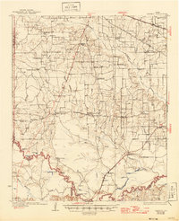
1930 Map of Bassett
USGS Topo · Published 1946About this map
The St Louis Southwestern railroad and several early wagon routes, including the Clarksville Road, define the settlement patterns of this corner of Bowie County during the 1920s. Small community hubs like Dalby Springs and Bassett appear alongside a dense network of rural infrastructure, such as the County Line Sch and Hubbard Chapel. The southern portion of the sheet is dominated by the meandering Sulphur River and its associated wetlands, featuring family-named landmarks like Willow Bluff and White Cotton.
Find a feature on this map
62 named features on this map. Tap any name to fly to it.
Don’t see what you’re looking for? This feature index may not catch every label — zoom into the map to look around manually.
Map Details
Editions of this 1930 Bassett Map
2 editions found
Other maps of this area

1909 · New Boston
USGS Topo · 1:62,500

1910 · Linden
USGS Topo · 1:62,500

1914 · Daingerfield
USGS Topo · 1:62,500

1930 · Bassett
USGS Topo · 1:62,500

1950 · De Kalb
USGS Topo · 1:24,000

1950 · Oak Grove
USGS Topo · 1:24,000

1951 · De Kalb
USGS Topo · 1:24,000

1951 · Oak Grove
USGS Topo · 1:24,000

1951 · Avery
USGS Topo · 1:24,000

1951 · Daniels Chapel
USGS Topo · 1:24,000