
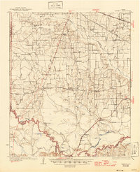
1930 Map of Bassett
USGS Topo · Published 1930About this map
Dalby Springs and the surrounding rural communities of Bowie and Cass Counties are mapped here during the transition into the 1930s. The landscape is defined by the winding course of the Sulphur River and its intricate drainage network, including Blythe Creek and Anderson Creek. Settlement patterns follow the high ground and prairie openings, such as Caughorn Prairie, where numerous country schools and churches supported a dispersed agrarian population. Local infrastructure at this time relied on a mix of old ways and new, from the Stephenson Ferry Bridge crossing the river to the presence of an Oil Well near Noadmore Corners. The map documents the vital rail links of the Texas and Pacific and the St Louis Southwestern railroads, which connected small nodes like Bassett and Darden to the wider region, while early arterial routes like Old Boston Road still traced the older path of Texas travel.
Find a feature on this map
68 named features on this map. Tap any name to fly to it.
Don’t see what you’re looking for? This feature index may not catch every label — zoom into the map to look around manually.
Map Details
Editions of this 1930 Bassett Map
2 editions found
Other maps of this area

1909 · New Boston
USGS Topo · 1:62,500

1910 · Linden
USGS Topo · 1:62,500

1914 · Daingerfield
USGS Topo · 1:62,500

1950 · De Kalb
USGS Topo · 1:24,000

1950 · Oak Grove
USGS Topo · 1:24,000

1951 · De Kalb
USGS Topo · 1:24,000

1951 · Oak Grove
USGS Topo · 1:24,000

1951 · Avery
USGS Topo · 1:24,000

1951 · Daniels Chapel
USGS Topo · 1:24,000

1953 · Texarkana
USGS Topo · 1:250,000