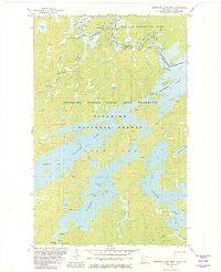
1981 Map of Basswood Lake West
USGS Topo · Published 1982About this map
Canada and United States border waters define this landscape of interconnected lakes and channels during the early 1980s. The map illustrates a complex network of portages and rapids along the Basswood River, where Lower Basswood Falls, Wheelbarrow Falls, and Basswood Falls mark the rugged descent of the watershed. Large expanses of water including Jackfish Bay, Pipestone Bay, and Hoist Bay are punctuated by numerous islands like New York Island and Gary Island. This survey captures the region within the Boundary Waters Canoe Area Wilderness and Superior National Forest, highlighting the transition from Minnesota to Ontario. The absence of roads and the reliance on Portage routes and a lone Gaging Station underscores the primitive nature of the wilderness corridor before modern developments altered these historic canoe routes.
Find a feature on this map
48 named features on this map. Tap any name to fly to it.
Don’t see what you’re looking for? This feature index may not catch every label — zoom into the map to look around manually.
Map Details
Editions of this 1981 Basswood Lake West Map
2 editions found
Other maps of this area

1933 · Ely
USGS Topo · 1:62,500

1939 · Ely
USGS Topo · 1:62,500

1954 · Two Harbors
USGS Topo · 1:250,000

1957 · Two Harbors
USGS Topo · 1:250,000

1957 · Gabbro Lake
USGS Topo · 1:62,500

1957 · Basswood Lake
USGS Topo · 1:62,500

1957 · Quetico
USGS Topo · 1:250,000

1958 · Two Harbors
USGS Topo · 1:250,000

1963 · Fourtown Lake
USGS Topo · 1:24,000
1963 · Friday Bay
USGS Topo · 1:24,000