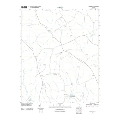
2011 Map of Bastonville
USGS Topo · Published 2011About this map
Bastonville and the nearby crossroads of Reese and Harts anchor this pocket of rural Georgia, defined by a dense network of family cemeteries and small creek branches. The map reveals a deeply rooted landscape where family names—such as Ricketson, Abbott, Norris, Usry, and Kelly—are preserved through dozens of burial grounds scattered across the countryside. Agricultural and early industrial history is evidenced by Blankenship Mill and Blankenship Pond in the south, while traditional crossings like Munns Ford suggest long-established travel routes over Little Brier Creek. The terrain is finely dissected by watercourses including Beechtree Creek, Rocky Comfort Creek, and McLean Creek, illustrating the drainage patterns that have historically shaped farm boundaries and settlement placement in this region of Warren County.
Find a feature on this map
79 named features on this map. Tap any name to fly to it.
Don’t see what you’re looking for? This feature index may not catch every label — zoom into the map to look around manually.
Map Details
Editions of this 2011 Bastonville Map
This is the sole edition of this map. No revisions or reprints were ever made.
Other maps of this area

1920 · Stapleton
USGS Topo · 1:62,500

1922 · Harlem
USGS Topo · 1:62,500

1948 · Harlem
USGS Topo · 1:62,500

1948 · Stapleton
USGS Topo · 1:62,500

1948 · Thomson East
USGS Topo · 1:24,000

1950 · Dearing
USGS Topo · 1:24,000

1950 · Wrens
USGS Topo · 1:24,000
1950 · Bowdens Pond
USGS Topo · 1:24,000

1953 · Athens
USGS Topo · 1:250,000

1958 · Athens
USGS Topo · 1:250,000