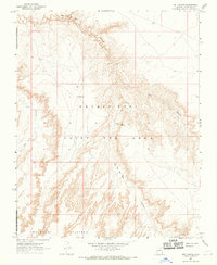
1967 Map of Bat Canyon
USGS Topo · Published 1969About this map
Ha Ho No Geh Canyon and Coal Mine Canyon dominate this high-desert landscape in Coconino County, illustrating the intricate drainage patterns of the Moenkopi Plateau. Recorded during a 1967 field check, the survey details the infrastructure within the Navajo-Hopi Joint Use Area, including a solitary Windmill and a Water Tank near Nez Spring. This specific area reflects the intersection of natural resource extraction and indigenous land use, clearly marking the site of a Coal Mine near the western rim of its namesake canyon. The topographical detail reveals the sharp elevation changes between the flat-topped plateau and the deep, eroded channels of Bat Canyon, providing a precise look at the geography of the Navajo Indian Reservation Boundary before subsequent land divisions altered the administrative landscape.
Find a feature on this map
12 named features on this map. Tap any name to fly to it.
Don’t see what you’re looking for? This feature index may not catch every label — zoom into the map to look around manually.
Map Details
Editions of this 1967 Bat Canyon Map
2 editions found
Other maps of this area

1883 · Marsh Pass
USGS Topo · 1:250,000

1883 · Tusayan
USGS Topo · 1:250,000

1886 · Tusayan
USGS Topo · 1:250,000

1886 · San Francisco Mtns
USGS Topo · 1:250,000

1886 · Echo Cliffs
USGS Topo · 1:250,000

1891 · San Francisco Mtns
USGS Topo · 1:250,000

1891 · Echo Cliffs
USGS Topo · 1:250,000

1892 · Marsh Pass
USGS Topo · 1:250,000

1894 · San Francisco Mtns
USGS Topo · 1:250,000

1899 · San Francisco Mtns
USGS Topo · 1:250,000