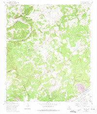
1967 Map of Bat Cave
USGS Topo · Published 1975About this map
Cibolo Creek and the West Fork Dry Comal Creek carve through this landscape along the border of Comal and Bexar counties. This 1967 survey highlights a subterranean geography as much as a surface one, centering on the Natural Bridge Caverns and the namesake Bat Cave. The terrain is marked by numerous family-named burial grounds including Romple Cem, Kunkel Cem, and Weitbacher Cem, reflecting the deep-rooted agricultural settlement of the Hill Country. In the southeast, the small community of Ogden sits at the junction of the Missouri Pacific and Missouri Kansas Texas railroads. Several Gravel Pits and a Water Tank near the tracks suggest a local economy tied to both extraction and the vital rail corridor connecting the region's larger trade centers.
Find a feature on this map
27 named features on this map. Tap any name to fly to it.
Don’t see what you’re looking for? This feature index may not catch every label — zoom into the map to look around manually.
Map Details
Editions of this 1967 Bat Cave Map
2 editions found
Other maps of this area

1920 · Smithsons Valley
USGS Topo · 1:62,500

1925 · Hunter No 3
USGS Topo · 1:48,000

1927 · New Braunfels
USGS Topo · 1:62,500

1927 · Smithson Valley
USGS Topo · 1:62,500

1929 · Hunter
USGS Topo · 1:62,500

1929 · Smithson Valley
USGS Topo · 1:62,500

1940 · Smithson Valley
USGS Topo · 1:62,500

1953 · Schertz
USGS Topo · 1:24,000

1953 · Bulverde
USGS Topo · 1:24,000

1953 · Bat Cave
USGS Topo · 1:24,000