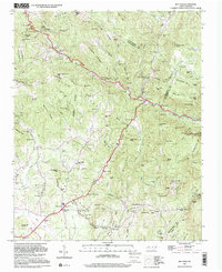
1997 Map of Bat Cave
USGS Topo · Published 2001About this map
The Broad River carves through the dramatic gap between Chimney Rock Mtn and Bluerock Mtn, anchoring a landscape defined by sharp elevation changes and high mountain passes. Settlement patterns are concentrated along the winding watercourses and the historic Tennessee Road, with the community of Gerton established near Hickorynut Gap. This 1997 photo-inspection, based on earlier topographic surveys, captures the region's complex drainage network where Hickory Creek and Reedypatch Creek feed the larger river system.
Find a feature on this map
100 named features on this map. Tap any name to fly to it.
Don’t see what you’re looking for? This feature index may not catch every label — zoom into the map to look around manually.
Map Details
Editions of this 1997 Bat Cave Map
This is the sole edition of this map. No revisions or reprints were ever made.
Other maps of this area

1900 · Mount Mitchell
USGS Topo · 1:125,000

1902 · Mount Mitchell
USGS Topo · 1:125,000

1907 · Saluda
USGS Topo · 1:125,000

1935 · Batcave
USGS Topo · 1:24,000

1935 · Hendersonville
USGS Topo · 1:24,000

1935 · Black Mountain
USGS Topo · 1:24,000

1935 · Fishtop
USGS Topo · 1:24,000

1936 · Fruitland
USGS Topo · 1:24,000

1941 · Black Mountain
USGS Topo · 1:24,000

1942 · Fruitland
USGS Topo · 1:24,000