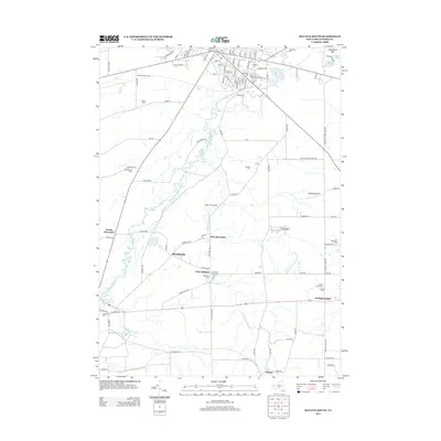
2013 Map of Batavia South
USGS Topo · Published 2013About this map
Little Tonawanda Creek and the meandering Tonawanda Creek define the agrarian landscape south of Batavia during the early 2010s. This survey detail includes the southern reaches of the city, where several established burial grounds such as Grandview Cemetery, Batavia Cemetery, and Saint Joseph Cemetery are situated. The map provides a look at the rural crossroads and small hamlets that comprise the Genesee County countryside, including Brookville, Bethany Center, and Linden. Agriculture remains the primary footprint on the land, evidenced by named operations like Misty Mountain Farm and the Lor-Rob Dairy Farm. For genealogists, the map is particularly valuable for its precise location of numerous rural cemeteries, such as Mt Pleasant Cemetery and the West Bethany Rural Cemetery, many tucked away along country roads like Lovers Lane Road.
Find a feature on this map
109 named features on this map. Tap any name to fly to it.
Don’t see what you’re looking for? This feature index may not catch every label — zoom into the map to look around manually.
Map Details
Editions of this 2013 Batavia South Map
This is the sole edition of this map. No revisions or reprints were ever made.
Other maps of this area

1897 · Albion
USGS Topo · 1:62,500

1897 · Medina
USGS Topo · 1:62,500

1904 · Batavia
USGS Topo · 1:62,500

1905 · Attica
USGS Topo · 1:62,500

1944 · Alexander
USGS Topo · 1:31,680

1944 · Byron
USGS Topo · 1:31,680

1944 · Stafford
USGS Topo · 1:31,680

1949 · Attica
USGS Topo · 1:62,500

1949 · Alexander
USGS Topo · 1:24,000
1949 · Attica
USGS Topo · 1:24,000