
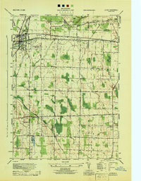
1944 Map of Byron
USGS Topo · Published 1944About this map
Byron and its surrounding agricultural landscape are defined by the convergence of major rail corridors and glacial waterways during the mid-1940s. The New York Central System (West Shore) railroad bisects the township, supporting established hubs like South Byron and West Bergen. To the north, the Bergen Swamp Wild-Life Sanctuary marks a distinct ecological pocket adjacent to the winding course of Black Creek.
Find a feature on this map
82 named features on this map. Tap any name to fly to it.
Don’t see what you’re looking for? This feature index may not catch every label — zoom into the map to look around manually.
Map Details
Editions of this 1944 Byron Map
This is the sole edition of this map. No revisions or reprints were ever made.
Other maps of this area

1897 · Albion
USGS Topo · 1:62,500

1899 · Brockport
USGS Topo · 1:62,500

1904 · Batavia
USGS Topo · 1:62,500

1904 · Caledonia
USGS Topo · 1:62,500

1934 · Brockport
USGS Topo · 1:24,000

1935 · Churchville
USGS Topo · 1:24,000

1944 · Churchville
USGS Topo · 1:31,680

1944 · Holley
USGS Topo · 1:31,680

1944 · Stafford
USGS Topo · 1:31,680
1944 · Le Roy
USGS Topo · 1:31,680