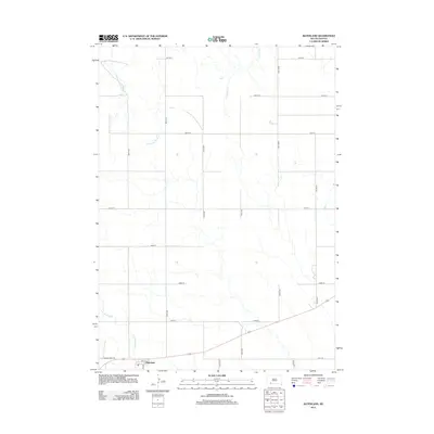
2012 Map of Batesland
USGS Topo · Published 2012About this map
Batesland serves as the primary hub in this corner of the Pine Ridge region, situated near the intersection of Ash St and a primary east-west route. The landscape is defined by the winding course of the Little White River in the southwest, while American Horse Cr and No Flesh Cr drain the northern sections of the quadrangle. The area's administrative center is marked by the Po, anchoring the small community against a vast grid of section roads including 287th St and 198th Ave. This survey illustrates the persistent section-line road network typical of the Great Plains, where agricultural transit routes are etched into the prairie landscape around the river valley.
Find a feature on this map
20 named features on this map. Tap any name to fly to it.
Don’t see what you’re looking for? This feature index may not catch every label — zoom into the map to look around manually.
Map Details
Editions of this 2012 Batesland Map
This is the sole edition of this map. No revisions or reprints were ever made.
Other maps of this area

1955 · Hot Springs
USGS Topo · 1:250,000

1955 · Martin
USGS Topo · 1:250,000

1958 · Martin
USGS Topo · 1:250,000
1981 · Wakpamani
USGS Topo · 1:25,000

1981 · Yellow Bear Camp
USGS Topo · 1:25,000

1981 · Allen
USGS Topo · 1:25,000

1981 · Ecoffey Lake
USGS Topo · 1:25,000
1981 · Batesland
USGS Topo · 1:25,000

1981 · Swett
USGS Topo · 1:25,000

1983 · Martin
USGS Topo · 1:100,000