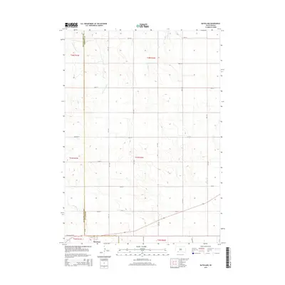
2015 Map of Batesland
USGS Topo · Published 2015About this map
Batesland serves as the primary hub in this southwestern South Dakota landscape, situated along the southern edge of the quadrangle near the Us-18 highway. The terrain is defined by a series of drainage systems that flow northward across the county line, which divides Oglala Lakota Co and Bennett Co. The Little White River cuts through the southwestern corner, joined by tributaries including American Horse Cr and No Flesh Cr. The map reveals a systematic grid of section lines and rural roads, such as Beer Run Rd and Wounded Knee Rd, which provide access to the agricultural parcels and open range characteristic of this region. This 2015 survey reflects the contemporary layout of the Pine Ridge area, documenting the persistence of these watercourses and the established roadway network that connects the scattered homesteads and local infrastructure.
Find a feature on this map
23 named features on this map. Tap any name to fly to it.
Don’t see what you’re looking for? This feature index may not catch every label — zoom into the map to look around manually.
Map Details
Editions of this 2015 Batesland Map
This is the sole edition of this map. No revisions or reprints were ever made.
Other maps of this area

1955 · Hot Springs
USGS Topo · 1:250,000

1955 · Martin
USGS Topo · 1:250,000

1958 · Martin
USGS Topo · 1:250,000
1981 · Wakpamani
USGS Topo · 1:25,000

1981 · Yellow Bear Camp
USGS Topo · 1:25,000

1981 · Allen
USGS Topo · 1:25,000

1981 · Ecoffey Lake
USGS Topo · 1:25,000
1981 · Batesland
USGS Topo · 1:25,000

1981 · Swett
USGS Topo · 1:25,000

1983 · Martin
USGS Topo · 1:100,000