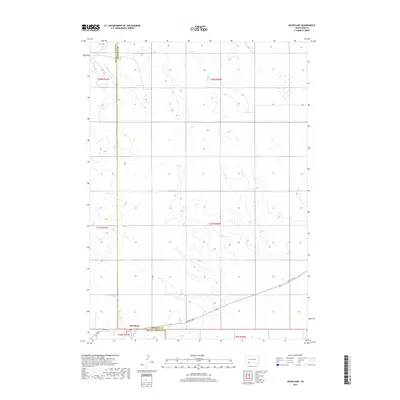
2017 Map of Batesland
USGS Topo · Published 2017About this map
The settlement of Batesland serves as a focal point in this 2017 survey, situated at the boundary between Oglala Lakota and Bennett counties. This western South Dakota landscape is defined by the winding course of the Little White River in the south, while northern drainages include American Horse Cr and No Flesh Cr. The map captures the intersection of rural life and transportation, where the local street grid of 1st St meets the regional corridor of Hwy 18, also known as Bennett Ave. The topography reveals a series of gradual plateaus and drainages characteristic of the Great Plains, illustrating how human settlement and road networks have been shaped by the river valleys and high prairie divides in this part of the Pine Ridge region.
Find a feature on this map
15 named features on this map. Tap any name to fly to it.
Don’t see what you’re looking for? This feature index may not catch every label — zoom into the map to look around manually.
Map Details
Editions of this 2017 Batesland Map
This is the sole edition of this map. No revisions or reprints were ever made.
Other maps of this area

1955 · Hot Springs
USGS Topo · 1:250,000

1955 · Martin
USGS Topo · 1:250,000

1958 · Martin
USGS Topo · 1:250,000
1981 · Wakpamani
USGS Topo · 1:25,000

1981 · Yellow Bear Camp
USGS Topo · 1:25,000

1981 · Allen
USGS Topo · 1:25,000

1981 · Ecoffey Lake
USGS Topo · 1:25,000
1981 · Batesland
USGS Topo · 1:25,000

1981 · Swett
USGS Topo · 1:25,000

1983 · Martin
USGS Topo · 1:100,000