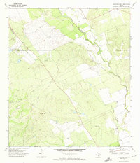
1971 Map of Batesville Hill
USGS Topo · Published 1974About this map
Leona River meanders through the boundary lands of South Texas in this 1971 survey, following a winding course that defines the local drainage. The landscape is marked by the distinct elevation of Batesville Hill, a prominent feature in an area otherwise characterized by intermittent watercourses like Gallina Creek and Camp Lake Slough. Human activity is primarily agricultural and industrial, evidenced by a remote Gravel Pit and several drill holes and wells scattered across the terrain. A solitary Grave located near the riverbank offers a specific point of interest for genealogists tracing early inhabitants of the Uvalde and Zavala county line. The infrastructure of the early 1970s is represented by a small Landing Strip and the County Line Tank, illustrating the water management and transportation needs of this cattle and brush country.
Find a feature on this map
11 named features on this map. Tap any name to fly to it.
Don’t see what you’re looking for? This feature index may not catch every label — zoom into the map to look around manually.
Map Details
Editions of this 1971 Batesville Hill Map
This is the sole edition of this map. No revisions or reprints were ever made.
Other maps of this area

1898 · Uvalde
USGS Topo · 1:125,000

1899 · Uvalde
USGS Topo · 1:125,000

1939 · La Pryor
USGS Topo · 1:62,500

1953 · Crystal City
USGS Topo · 1:250,000

1954 · San Antonio
USGS Topo · 1:250,000

1955 · Crystal City
USGS Topo · 1:250,000

1957 · San Antonio
USGS Topo · 1:250,000

1957 · Batesville
USGS Topo · 1:62,500

1960 · Pulliam Ranch
USGS Topo · 1:24,000

1961 · Crystal City
USGS Topo · 1:250,000