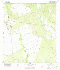
1972 Map of Batesville
USGS Topo · Published 1974About this map
Batesville serves as the focal point of this 1970s South Texas survey, situated where the Leona River meanders through Zavala County. The landscape is defined by its agricultural and ranching utility, marked by an extensive network of Well sites and livestock-related infrastructure such as Storage Bins and a central Water Tank in town. The drainage patterns are intricate, with Elm Creek and Liveoak Creek feeding into the river system, while Gallina Slough marks the lower reaches of the quadrangle. A small Landing Strip and Substation northwest of the town center indicate the localized transportation and utility developments of the era. The map's contour lines and numerous borehole locations illustrate a region deeply connected to groundwater management and rural industry, evidenced by the presence of a Gravel Pit along the river's edge.
Find a feature on this map
12 named features on this map. Tap any name to fly to it.
Don’t see what you’re looking for? This feature index may not catch every label — zoom into the map to look around manually.
Map Details
Editions of this 1972 Batesville Map
This is the sole edition of this map. No revisions or reprints were ever made.
Other maps of this area

1898 · Uvalde
USGS Topo · 1:125,000

1899 · Uvalde
USGS Topo · 1:125,000

1928 · Frio Town
USGS Topo · 1:62,500

1942 · Divot
USGS Topo · 1:62,500

1953 · Crystal City
USGS Topo · 1:250,000

1954 · San Antonio
USGS Topo · 1:250,000

1955 · Crystal City
USGS Topo · 1:250,000

1956 · Divot
USGS Topo · 1:62,500

1957 · San Antonio
USGS Topo · 1:250,000

1957 · Batesville
USGS Topo · 1:62,500