
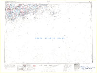
1963 Map of Bath
USGS Topo · Published 1963About this map
Maine Central RR tracks thread through the complex coastal geography of the Midcoast in the early 1960s, connecting historic shipbuilding and maritime centers. The landscape is dominated by the estuaries of the Androscoggin River, Kennebec River, and Sheepscot River, which converge at the vital inland waters of Merrymeeting Bay. This survey captures the intricate network of peninsulas and islands that defined the region's economy, from the commercial hub of Bath and the educational center at Brunswick to the outer reaches of Monhegan Island and the Georges Islands. Coastal travel is anchored by U.S. 1, while more remote fishing communities such as New Harbor and Friendship remain tied to the surrounding North Atlantic Ocean. The map provides a clear record of the jurisdictional boundaries between Cumberland, Sagadahoc, Lincoln, and Knox counties during this period of mid-century development.
Find a feature on this map
42 named features on this map. Tap any name to fly to it.
Don’t see what you’re looking for? This feature index may not catch every label — zoom into the map to look around manually.
Map Details
Editions of this 1963 Bath Map
2 editions found
Other maps of this area

1892 · Gardiner
USGS Topo · 1:62,500

1892 · Freeport
USGS Topo · 1:62,500

1893 · Small Point
USGS Topo · 1:62,500

1893 · Casco Bay
USGS Topo · 1:62,500

1893 · Wiscasset
USGS Topo · 1:62,500

1893 · Boothbay
USGS Topo · 1:62,500

1894 · Bath
USGS Topo · 1:62,500

1904 · Deer Isle
USGS Topo · 1:62,500

1904 · Swan Island
USGS Topo · 1:62,500

1904 · Vinalhaven
USGS Topo · 1:62,500