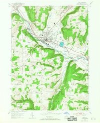
1953 Map of Bath
USGS Topo · Published 1955About this map
The Bath village center serves as the hub of this 1950s survey, showing a dense network of civic and institutional landmarks including the County Home, Jail, and the Haverling High Sch. The town is framed by the Cohocton River and a dual-railroad corridor featuring the Erie R.R. and the Delaware Lackawanna and Western RR, highlighting the importance of the valley as a transportation artery. To the west, the sprawling Veterans Administration Center occupies a significant tract of land near the riverbanks.
Find a feature on this map
54 named features on this map. Tap any name to fly to it.
Don’t see what you’re looking for? This feature index may not catch every label — zoom into the map to look around manually.
Map Details
Editions of this 1953 Bath Map
Other maps of this area

1903 · Hammondsport
USGS Topo · 1:62,500

1910 · Bath
USGS Topo · 1:62,500

1914 · Corning
USGS Topo · 1:62,500

1924 · Woodhull
USGS Topo · 1:48,000

1926 · Woodhull
USGS Topo · 1:62,500

1944 · Woodhull
USGS Topo · 1:62,500

1944 · Corning
USGS Topo · 1:62,500

1950 · Elmira
USGS Topo · 1:250,000

1953 · Campbell
USGS Topo · 1:24,000

1953 · Cameron
USGS Topo · 1:24,000