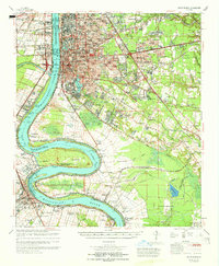
1965 Map of Baton Rouge
USGS Topo · Published 1965About this map
The Mississippi River defines the landscape of this mid-1960s survey, anchoring a region where dense urban development in Baton Rouge meets the legacy of the river's plantation economy. Significant river features like Missouri Bend, Plaquemine Point, and Manchac Point reveal the waterway's winding path through West Baton Rouge and Iberville parishes. On the west bank, the industrial character of Port Allen and Plaquemine is evident, while the east bank showcases the sprawling campus of Louisiana State University and A & M College and the Baton Rouge Downtown Airport. Beyond the city, the map preserves the names of numerous historical estates such as St Louis Plantation, Evergreen Plantation, and Poplar Grove Plantation, illustrating how modern infrastructure began to overlay the traditional agricultural landscape during this era of growth.
Find a feature on this map
171 named features on this map. Tap any name to fly to it.
Don’t see what you’re looking for? This feature index may not catch every label — zoom into the map to look around manually.
Map Details
Editions of this 1965 Baton Rouge Map
This is the sole edition of this map. No revisions or reprints were ever made.
Other maps of this area

1892 · Donaldsonville
USGS Topo · 1:62,500

1906 · Bayou Sara
USGS Topo · 1:125,000

1908 · Baton Rouge
USGS Topo · 1:62,500

1934 · Denham Springs
USGS Topo · 1:62,500

1935 · Gonzales
USGS Topo · 1:31,680

1935 · Chicot Lake
USGS Topo · 1:62,500

1936 · White Castle
USGS Topo · 1:62,500

1939 · Zachary
USGS Topo · 1:62,500

1939 · Denham Springs
USGS Topo · 1:62,500

1939 · Baton Rouge
USGS Topo · 1:62,500