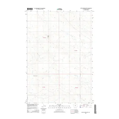
2015 Map of Battle Creek Butte
USGS Topo · Published 2015About this map
Battle Creek Butte rises as a prominent landmark in this corner of Butte County, South Dakota, anchoring a landscape defined by its high plains drainage patterns. The area is dissected by several named watercourses, including Battle Cr in the north and the meandering Porcupine Cr and Antelope Cr to the south. These ephemeral and perennial streams have carved distinct topographic features such as Hawks Nest Draw, which illustrates the erosion-prone nature of the local terrain. Transportation across this rural expanse is facilitated by Old Highway 85, running north-south through the eastern townships, and Camp Crook Rd at the southwestern edge. The map reflects the enduring cadastral organization of the region, showing the township and range divisions of T13N and T12N that have governed land use and ranching boundaries for over a century.
Find a feature on this map
11 named features on this map. Tap any name to fly to it.
Don’t see what you’re looking for? This feature index may not catch every label — zoom into the map to look around manually.
Map Details
Editions of this 2015 Battle Creek Butte Map
This is the sole edition of this map. No revisions or reprints were ever made.
Other maps of this area

1905 · Indian
USGS Topo · 1:62,500

1906 · Two Top
USGS Topo · 1:62,500

1907 · Belle Fourche
USGS Topo · 1:125,000

1935 · Harding
USGS Topo · 1:125,000

1953 · Rapid City
USGS Topo · 1:250,000

1954 · Lemmon
USGS Topo · 1:250,000

1957 · Lemmon
USGS Topo · 1:250,000

1957 · Rapid City
USGS Topo · 1:250,000
1965 · Antelope Butte
USGS Topo · 1:24,000
1965 · Two Top Butte West
USGS Topo · 1:24,000