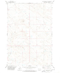
1978 Map of Battle Creek Butte
USGS Topo · Published 1978About this map
Battle Creek Butte anchors this 1978 survey of the western South Dakota plains, a landscape defined by an intricate network of intermittent watercourses and high prairie terrain. The topographic detail follows the winding paths of Battle Creek and Porcupine Creek, illustrating how the drainage patterns of Hawks Nest Draw and Antelope Creek have sculpted the rangeland. Unlike maps of more populated regions, this sheet highlights the isolation of the western plains, where a single Well represents a critical human imprint for ranching and livestock in an otherwise open environment. The survey captures the area just as modern photogrammetric methods were refining the representation of this sparsely settled corner of Butte County.
Find a feature on this map
7 named features on this map. Tap any name to fly to it.
Don’t see what you’re looking for? This feature index may not catch every label — zoom into the map to look around manually.
Map Details
Editions of this 1978 Battle Creek Butte Map
This is the sole edition of this map. No revisions or reprints were ever made.
Other maps of this area

1905 · Indian
USGS Topo · 1:62,500

1906 · Two Top
USGS Topo · 1:62,500

1907 · Belle Fourche
USGS Topo · 1:125,000

1935 · Harding
USGS Topo · 1:125,000

1953 · Rapid City
USGS Topo · 1:250,000

1954 · Lemmon
USGS Topo · 1:250,000

1957 · Lemmon
USGS Topo · 1:250,000

1957 · Rapid City
USGS Topo · 1:250,000
1965 · Antelope Butte
USGS Topo · 1:24,000
1965 · Two Top Butte West
USGS Topo · 1:24,000