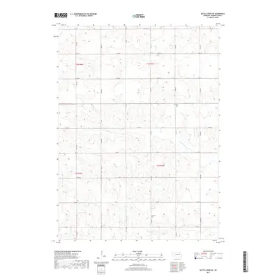
2017 Map of Battle Creek SW
USGS Topo · Published 2017About this map
The rolling agricultural uplands of Madison County are defined by a regular grid of section-line roads and the winding path of N Fork Union Cr. This landscape reflects the enduring rural character of northeastern Nebraska, where transport and community sites are organized around a precise township and range system including t22n r4w and t21n r3w. Small communal landmarks provide vital clues for genealogists and local historians, particularly the Iowa Valley Cem in the northern reaches and the Evangelical Cem further south along 542nd Ave. The drainage of Battle Cr clips the northwestern corner, while an extensive network of numbered routes like 831st Rd and 830th Rd connects the scattered farmsteads across the prairie.
Find a feature on this map
23 named features on this map. Tap any name to fly to it.
Don’t see what you’re looking for? This feature index may not catch every label — zoom into the map to look around manually.
Map Details
Editions of this 2017 Battle Creek SW Map
This is the sole edition of this map. No revisions or reprints were ever made.
Other maps of this area

1955 · Fremont
USGS Topo · 1:250,000

1957 · Fremont
USGS Topo · 1:250,000

1958 · Fremont
USGS Topo · 1:250,000

1963 · Battle Creek
USGS Topo · 1:24,000

1963 · Emerick
USGS Topo · 1:24,000

1963 · Closter SE
USGS Topo · 1:24,000
1963 · Closter NE
USGS Topo · 1:24,000

1963 · Battle Creek SE
USGS Topo · 1:24,000

1963 · Battle Creek SW
USGS Topo · 1:24,000
1966 · Newman Grove
USGS Topo · 1:24,000