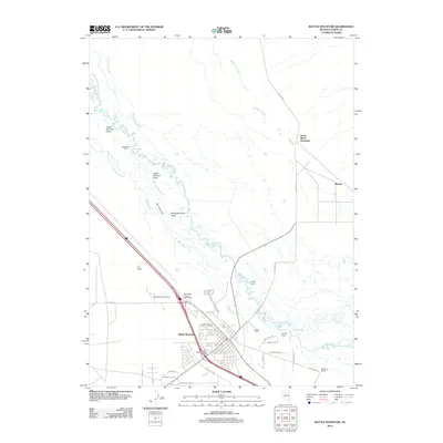
2012 Map of Battle Mountain
USGS Topo · Published 2012About this map
Battle Mountain sits at the vital confluence of the Humboldt River and Reese River, serving as a central hub in Lander County. This survey illustrates the intricate network of water management features necessary for the high desert valley, including the Twenty Five Ditch, Gimble Two Ditch, and McIntyre Slough. The land surrounding the town is defined by a series of significant ranching operations and agricultural fields such as the Licking Ranch, Broyles Ranch, and Slaughterhouse Field. Beyond the urban center, the map identifies specific community landmarks like TeMoak Indian Housing and the Battle Mountain Post Office, alongside the more remote Buckbrush Cabin and Rennox. The intersection of heavy transit and local agriculture is evident through the placement of the West Battle Mountain Interchange and the numerous named fields that line the riverbanks.
Find a feature on this map
41 named features on this map. Tap any name to fly to it.
Don’t see what you’re looking for? This feature index may not catch every label — zoom into the map to look around manually.
Map Details
Editions of this 2012 Battle Mountain Map
This is the sole edition of this map. No revisions or reprints were ever made.
Other maps of this area

1932 · Sonoma Range
USGS Topo · 1:250,000

1939 · Sonoma Range
USGS Topo · 1:250,000

1940 · Antler Peak
USGS Topo · 1:62,500

1943 · Antler Peak
USGS Topo · 1:62,500

1955 · Winnemucca
USGS Topo · 1:250,000

1957 · Battle Mountain
USGS Topo · 1:62,500

1958 · Winnemucca
USGS Topo · 1:250,000

1962 · Winnemucca
USGS Topo · 1:250,000

1965 · Russells
USGS Topo · 1:24,000
1965 · Izzenhood Spring
USGS Topo · 1:24,000