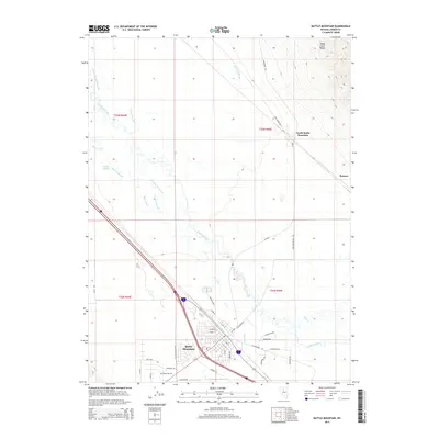
2015 Map of Battle Mountain
USGS Topo · Published 2015About this map
The Humboldt River and its confluence with the Reese River anchor this 2015 study of the Lander County landscape. The topography transitions from the valley floor to the rising elevations of the Sheep Creek Range in the northeast, where North Battle Mountain stands as a prominent landmark. The settlement of Battle Mountain shows a developed grid of streets such as Marvel Rd and Kayci Ave, while the surrounding terrain is heavily modified by an extensive irrigation network.
Find a feature on this map
44 named features on this map. Tap any name to fly to it.
Don’t see what you’re looking for? This feature index may not catch every label — zoom into the map to look around manually.
Map Details
Editions of this 2015 Battle Mountain Map
This is the sole edition of this map. No revisions or reprints were ever made.
Other maps of this area

1932 · Sonoma Range
USGS Topo · 1:250,000

1939 · Sonoma Range
USGS Topo · 1:250,000

1940 · Antler Peak
USGS Topo · 1:62,500

1943 · Antler Peak
USGS Topo · 1:62,500

1955 · Winnemucca
USGS Topo · 1:250,000

1957 · Battle Mountain
USGS Topo · 1:62,500

1958 · Winnemucca
USGS Topo · 1:250,000

1962 · Winnemucca
USGS Topo · 1:250,000

1965 · Russells
USGS Topo · 1:24,000
1965 · Izzenhood Spring
USGS Topo · 1:24,000