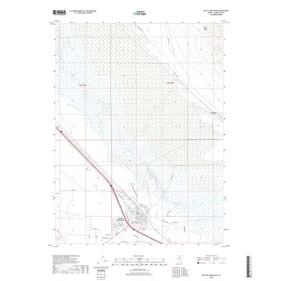
2018 Map of Battle Mountain
USGS Topo · Published 2018About this map
Battle Mountain sits at the confluence of several vital Great Basin waterways, where the Reese River and Rock Creek meet the winding Humboldt River. This 2018 survey documents the intricate network of irrigation channels essential to the local valley, including the Twenty-five Ditch, Gimble One Ditch, and Gimble Two Ditch. These man-made features weave through natural depressions like Outside Slough and Mcintyre Slough, illustrating the managed hydrology of the Nevada desert. To the northeast, the terrain rises into the foothills of the Sheep Creek Range, providing a sharp contrast to the flat basin floor where the settlement of Rennox and the Battle Mountain City Cem are situated. The grid of the town site is meticulously detailed, showing the layout of residential streets from Altenburg Ave to Lemaire Rd alongside the transit corridor of the Interstate.
Find a feature on this map
51 named features on this map. Tap any name to fly to it.
Don’t see what you’re looking for? This feature index may not catch every label — zoom into the map to look around manually.
Map Details
Editions of this 2018 Battle Mountain Map
This is the sole edition of this map. No revisions or reprints were ever made.
Other maps of this area

1932 · Sonoma Range
USGS Topo · 1:250,000

1939 · Sonoma Range
USGS Topo · 1:250,000

1940 · Antler Peak
USGS Topo · 1:62,500

1943 · Antler Peak
USGS Topo · 1:62,500

1955 · Winnemucca
USGS Topo · 1:250,000

1957 · Battle Mountain
USGS Topo · 1:62,500

1958 · Winnemucca
USGS Topo · 1:250,000

1962 · Winnemucca
USGS Topo · 1:250,000

1965 · Russells
USGS Topo · 1:24,000
1965 · Izzenhood Spring
USGS Topo · 1:24,000