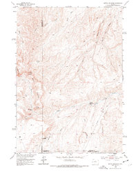
1952 Map of Battle Mountain
USGS Topo · Published 1977About this map
Battle Mountain dominates this high-altitude landscape in north-central Wyoming, where the headwaters of the Nowood River and Bates Creek carve through the terrain. The 1952 field check captures a remote pocket of ranching and homesteading history, marked by the Orchard Bates Creek Ranch and the Rate Homestead. This map serves as a vital record for researchers of local land use, showing how early 20th-century settlers utilized the proximity of water sources like Dead Indian Spring and the Buffalo Springs Creek network. The complex drainage patterns of Brome Draw and the Stove Canyon Creek canyon reveal the difficulty of the landscape, while the presence of the Mexican Lakes and family-named landmarks like Hawks Butte provide specific points of reference for genealogists tracing regional land claims near the Washakie, Hot Springs, and Natrona county lines.
Find a feature on this map
19 named features on this map. Tap any name to fly to it.
Don’t see what you’re looking for? This feature index may not catch every label — zoom into the map to look around manually.
Map Details
Editions of this 1952 Battle Mountain Map
2 editions found
Other maps of this area

1952 · Cottonwood Pass
USGS Topo · 1:24,000

1952 · Sioux Pass
USGS Topo · 1:24,000

1952 · Arapahoe Butte
USGS Topo · 1:24,000

1952 · Battle Mountain
USGS Topo · 1:24,000

1952 · Bull Mountain
USGS Topo · 1:24,000

1955 · Arminto
USGS Topo · 1:250,000

1958 · Arminto
USGS Topo · 1:250,000

1962 · Arminto
USGS Topo · 1:250,000

1966 · Sand Point
USGS Topo · 1:24,000

1966 · Bader Draw
USGS Topo · 1:24,000