
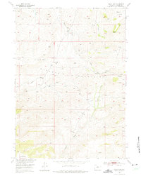
1952 Map of Sioux Pass
USGS Topo · Published 1953About this map
The Big Horn Mountains dominate this high-altitude terrain in Natrona County, where the landscape is defined by its deep drainage networks and dramatic topographical shifts. In the early 1950s, this area remained largely remote, anchored by the Welby Ranch in the southern reaches. The map details the complex system of waterways feeding the region, including Bear Creek, Trout Creek, and Clear Creek, which carve through the steep elevations.
Find a feature on this map
12 named features on this map. Tap any name to fly to it.
Don’t see what you’re looking for? This feature index may not catch every label — zoom into the map to look around manually.
Map Details
Editions of this 1952 Sioux Pass Map
2 editions found
Other maps of this area

1952 · Cottonwood Pass
USGS Topo · 1:24,000

1952 · Badwater
USGS Topo · 1:24,000

1952 · Lysite SE
USGS Topo · 1:24,000

1952 · Badwater NE
USGS Topo · 1:24,000

1952 · Battle Mountain
USGS Topo · 1:24,000

1952 · Badwater SE
USGS Topo · 1:24,000

1955 · Arminto
USGS Topo · 1:250,000

1958 · Arminto
USGS Topo · 1:250,000

1962 · Arminto
USGS Topo · 1:250,000
1967 · Cornell Gulch
USGS Topo · 1:24,000