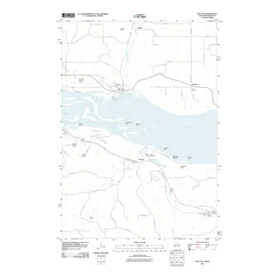
2010 Map of Bay City
USGS Topo · Published 2010About this map
The Mississippi River carves a complex course through this border region, defining the landscape around Bay City and Wacouta. This 2010 study reveals a diverse mix of aviation, recreation, and rural life, featuring the Red Wing Municipal Airport situated near the Catharine Pass. The river's influence is seen in features like Baldwin Island, Sawdust Bar, and Fishermans Point, which speak to the long history of river navigation and industry along these banks. Inland, the terrain rises toward Jackson Bluff and Rattlesnake Bluff, while smaller waterways like Isabelle Creek and Bullard Creek drain the surrounding hills.
Find a feature on this map
62 named features on this map. Tap any name to fly to it.
Don’t see what you’re looking for? This feature index may not catch every label — zoom into the map to look around manually.
Map Details
Editions of this 2010 Bay City Map
This is the sole edition of this map. No revisions or reprints were ever made.
Other maps of this area

1940 · Maiden Rock
USGS Topo · 1:62,500

1944 · Red Wing
USGS Topo · 1:62,500

1950 · Maiden Rock
USGS Topo · 1:62,500

1951 · Lake City
USGS Topo · 1:62,500

1952 · Red Wing
USGS Topo · 1:62,500

1953 · Saint Paul
USGS Topo · 1:250,000

1959 · Saint Paul
USGS Topo · 1:250,000

1968 · Goodhue East
USGS Topo · 1:24,000
1974 · Lake City NW
USGS Topo · 1:24,000
1974 · Lake City
USGS Topo · 1:24,000