1974 Map of Lake City
USGS Topo · Published 1977About this map
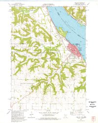
Lake Mississippi- River Pepin dominates the eastern horizon of this 1970s survey, acting as a broad corridor for the Burlington Northern and the Chicago Milwaukee St Paul and Pacific railroads. The river valley is flanked by dramatic elevations like Sugarloaf Bluff and Horrigan Hill, while the interior terrain is defined by a series of deep coulees, including Moran Coulee and Boston Coulee.
Find a feature on this map
46 named features on this map. Tap any name to fly to it.
Don’t see what you’re looking for? This feature index may not catch every label — zoom into the map to look around manually.
Map Details
Editions of this 1974 Lake City Map
This is the sole edition of this map. No revisions or reprints were ever made.
Other maps of this area

1932 · Wabasha
USGS Topo · 1:62,500

1935 · Arkansaw
USGS Topo · 1:48,000
1940 · Maiden Rock
USGS Topo · 1:62,500

1941 · Arkansaw
USGS Topo · 1:62,500

1942 · Arkansaw
USGS Topo · 1:62,500

1950 · Maiden Rock
USGS Topo · 1:62,500

1951 · Wabasha
USGS Topo · 1:62,500
1951 · Lake City
USGS Topo · 1:62,500

1953 · Saint Paul
USGS Topo · 1:250,000

1959 · Saint Paul
USGS Topo · 1:250,000