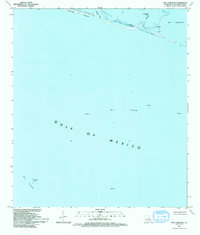
1993 Map of Bay Coquette
USGS Topo · Published 1994About this map
Pelican Island and the fragile marshes of the Mississippi River Delta dominate this coastal landscape, showing a region where the land dissolves into the Gulf of Mexico. This 1990s-era documentation highlights the heavy industrialization of the offshore environment, with an extensive Oil Field and numerous platforms and oil wells dotting the waters. The map reveals the intricate network of water transport and resource extraction, including the Scofield Bayou and a prominent Pipeline corridor. The presence of a Canal and Jetty underscores the human efforts to manage and navigate this shifting maritime boundary in Plaquemines Parish. For those researching the evolution of the Louisiana coastline, the layout of Bay Coquette and smaller features like Bayou Trouve provide a detailed look at the hydrology before significant modern land loss and subsidence.
Find a feature on this map
13 named features on this map. Tap any name to fly to it.
Don’t see what you’re looking for? This feature index may not catch every label — zoom into the map to look around manually.
Map Details
Editions of this 1993 Bay Coquette Map
This is the sole edition of this map. No revisions or reprints were ever made.
Other maps of this area

1892 · Quarantine
USGS Topo · 1:62,500

1893 · Forts
USGS Topo · 1:62,500

1893 · West Delta
USGS Topo · 1:62,500

1935 · Bastian Bay
USGS Topo · 1:31,680

1941 · Empire
USGS Topo · 1:62,500

1944 · Empire
USGS Topo · 1:62,500

1946 · Pass Du Bois
USGS Topo · 1:31,680

1946 · Pass Tante Phine
USGS Topo · 1:31,680

1947 · Buras
USGS Topo · 1:31,680

1947 · Fort St. Philip
USGS Topo · 1:31,680