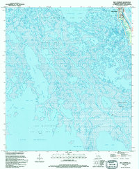
1994 Map of Bay Courant
USGS Topo · Published 1994About this map
Golden Meadow stands at the eastern edge of this coastal landscape, situated along the banks of Bayou Lafourche as it appeared in the mid-1990s. The map illustrates a complex coastal environment where natural waterways like Grand Bayou and Blue Bayou intersect with an extensive network of industrial canals and pipelines. This era is characterized by heavy resource extraction, evidenced by the expansive Golden Meadow Oil and Gas Field and the Courant Bay Gas Field, with numerous offshore Platforms dotted across Lake Raccourci. Local history is anchored by landmarks such as the Surgney Cem and the small settlement of Plaisance. The terrain is a maze of named water bodies, including Catfish Lake and Little Lake, separated by fragile marshlands and cuts like Chinois Pass and Pass a Jean.
Find a feature on this map
44 named features on this map. Tap any name to fly to it.
Don’t see what you’re looking for? This feature index may not catch every label — zoom into the map to look around manually.
Map Details
Editions of this 1994 Bay Courant Map
This is the sole edition of this map. No revisions or reprints were ever made.
Other maps of this area

1892 · Cheniere Caminada
USGS Topo · 1:62,500

1892 · Creole
USGS Topo · 1:62,500

1894 · Timbalier
USGS Topo · 1:62,500

1894 · Lake Felicity
USGS Topo · 1:62,500

1935 · Viguerie Canal
USGS Topo · 1:31,680

1935 · Bay Courant
USGS Topo · 1:31,680

1935 · Golden Meadow
USGS Topo · 1:31,680

1935 · Pelican Pass
USGS Topo · 1:31,680

1935 · Mink Bayou
USGS Topo · 1:31,680

1935 · Leeville
USGS Topo · 1:31,680