
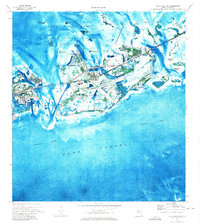
1943 Map of Bay Keys
USGS Topo · Published 1943About this map
The Gulf of Mexico dominates this mid-century maritime survey, documenting the intricate mangrove islands and tidal flats north of Key West. This military edition, based on 1943 field data and air photography, captures the remote character of Precinct 8 during the war years. Navigation is the primary focus, with detailed soundings and water passages like Bluefish Channel and Calda Channel threading through the shallow waters. A solitary navigation marker, Calda Channel Lt 1, anchors the western reaches of the sheet.
Find a feature on this map
10 named features on this map. Tap any name to fly to it.
Don’t see what you’re looking for? This feature index may not catch every label — zoom into the map to look around manually.
Map Details
Editions of this 1943 Bay Keys Map
This is the sole edition of this map. No revisions or reprints were ever made.
Other maps of this area

1921 · Sugar Loaf Key
USGS Topo · 1:62,500

1921 · Key West
USGS Topo · 1:62,500

1943 · Boca Chica
USGS Topo · 1:24,000

1943 · Key West
USGS Topo · 1:24,000

1943 · Snipe Keys
USGS Topo · 1:24,000

1943 · Cottrell Key
USGS Topo · 1:24,000

1962 · Key West
USGS Topo · 1:24,000

1963 · Cottrell Key
USGS Topo · 1:24,000

1971 · Key West
USGS Topo · 1:24,000
1971 · Boca Chica Key
USGS Topo · 1:24,000