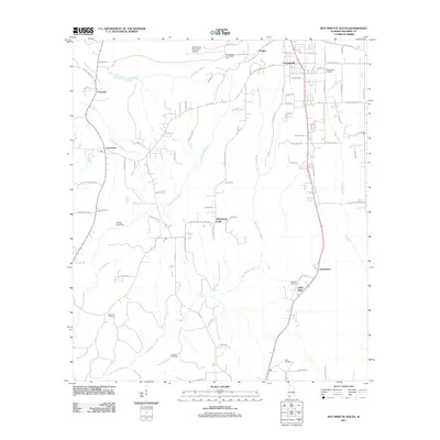
2011 Map of Bay Minette South
USGS Topo · Published 2011About this map
Bay Minette Creek and the Styx River define the drainage of this Baldwin County landscape, where small communities and family landholdings are connected by an intricate network of local roads. The map captures the suburban and rural character of the region south of the county seat, featuring established residential areas like Douglasville and Holly Hills. Infrastructure such as the Bay Minette Municipal Airport and the Ben May Fire Tower reflect the local economy's balance between transportation and forestry management.
Find a feature on this map
93 named features on this map. Tap any name to fly to it.
Don’t see what you’re looking for? This feature index may not catch every label — zoom into the map to look around manually.
Map Details
Editions of this 2011 Bay Minette South Map
This is the sole edition of this map. No revisions or reprints were ever made.
Other maps of this area

1920 · Robertsdale
USGS Topo · 1:62,500

1921 · Fairhope
USGS Topo · 1:62,500

1941 · Blakeley
USGS Topo · 1:31,680

1941 · Bay Minette
USGS Topo · 1:62,500

1941 · Robertsdale
USGS Topo · 1:62,500

1941 · Fairhope
USGS Topo · 1:62,500

1942 · Hurricane
USGS Topo · 1:31,680
1942 · Blakeley
USGS Topo · 1:31,680

1942 · Dyas
USGS Topo · 1:62,500

1943 · Robertsdale
USGS Topo · 1:62,500