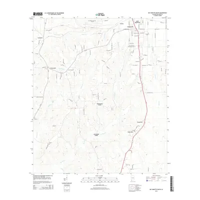
2014 Map of Bay Minette South
USGS Topo · Published 2014About this map
Spanish Fort and the southern reaches of Bay Minette anchor this coastal plain landscape in Baldwin County. The terrain is defined by a dense network of drainages including Bay Minette Cr, Whitehouse Cr, and the Styx River to the east. Higher ground supports a mix of academic and infrastructure hubs, most notably the James H Faulkner State Community Coll and the Bay Minette Municipal Airport. The area shows a transition from the established streets of Douglasville to the rural junctions of Whitehouse Forks and Crossroads. Genealogists will find several burial grounds mapped across the territory, such as Douglasville Cem, Stapleton Cem, and the more isolated Johnson Cem, providing a precise look at the community's historical footprint in the early 21st century.
Find a feature on this map
94 named features on this map. Tap any name to fly to it.
Don’t see what you’re looking for? This feature index may not catch every label — zoom into the map to look around manually.
Map Details
Editions of this 2014 Bay Minette South Map
This is the sole edition of this map. No revisions or reprints were ever made.
Other maps of this area

1920 · Robertsdale
USGS Topo · 1:62,500

1921 · Fairhope
USGS Topo · 1:62,500

1941 · Blakeley
USGS Topo · 1:31,680

1941 · Bay Minette
USGS Topo · 1:62,500

1941 · Robertsdale
USGS Topo · 1:62,500

1941 · Fairhope
USGS Topo · 1:62,500

1942 · Hurricane
USGS Topo · 1:31,680
1942 · Blakeley
USGS Topo · 1:31,680

1942 · Dyas
USGS Topo · 1:62,500

1943 · Robertsdale
USGS Topo · 1:62,500