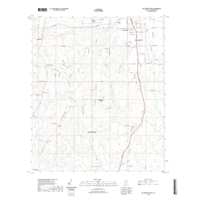
2020 Map of Bay Minette South
USGS Topo · Published 2020About this map
Bay Minette and the northern outskirts of Spanish Fort anchor this Baldwin County landscape, captured by the U.S. Geological Survey in 2020. The terrain is defined by a dense network of tributaries including Whitehouse Cr, Honeycut Cr, and Bay Minette Cr, which carve through the coastal plain toward the Styx River. Small settlements such as Douglasville, Whitehouse Forks, and Carpenter are connected by a mix of established state routes and rural connectors like Old Daphne Rd and Hurricane Rd. Local history is preserved in several community burial sites, including the Mutual Aid Cem, Johnson Cem, and Dean Cem. Modern infrastructure, notably the Bay Minette Municipal Airport and the Bay Minette Byp, illustrates the ongoing expansion of the region's transportation corridor between these growing Alabama municipalities.
Find a feature on this map
98 named features on this map. Tap any name to fly to it.
Don’t see what you’re looking for? This feature index may not catch every label — zoom into the map to look around manually.
Map Details
Editions of this 2020 Bay Minette South Map
This is the sole edition of this map. No revisions or reprints were ever made.
Other maps of this area

1920 · Robertsdale
USGS Topo · 1:62,500

1921 · Fairhope
USGS Topo · 1:62,500

1941 · Blakeley
USGS Topo · 1:31,680

1941 · Bay Minette
USGS Topo · 1:62,500

1941 · Robertsdale
USGS Topo · 1:62,500

1941 · Fairhope
USGS Topo · 1:62,500

1942 · Hurricane
USGS Topo · 1:31,680
1942 · Blakeley
USGS Topo · 1:31,680

1942 · Dyas
USGS Topo · 1:62,500

1943 · Robertsdale
USGS Topo · 1:62,500