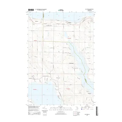
2014 Map of Bay Shore
USGS Topo · Published 2014About this map
The boundary of Charlevoix and Emmet counties splits this coastal landscape where Little Traverse Bay meets the mainland. North of the line, the community of Bay Shore sits along the shoreline, while the residential developments of Bay Shore Estates and Zenith Heights occupy the adjacent bluffs. The interior terrain is defined by the winding course of Horton Creek, which drains southward into the protected waters of Horton Bay and the larger expanse of Lake Charlevoix. This map reveals a settled rural landscape dotted with small family and community burial grounds, including N Bay Cemetery, Horton Bay Cemetery, and Dyer Cemetery. To the southeast, the area known as Wildwood transitions into the wooded uplands above the lake, while the historic connection between these harbor towns is maintained by routes like Boyne City Road and the Charlevoix-Boyne City Road.
Find a feature on this map
89 named features on this map. Tap any name to fly to it.
Don’t see what you’re looking for? This feature index may not catch every label — zoom into the map to look around manually.
Map Details
Editions of this 2014 Bay Shore Map
This is the sole edition of this map. No revisions or reprints were ever made.
Other maps of this area

1955 · Cheboygan
USGS Topo · 1:250,000

1958 · Cheboygan
USGS Topo · 1:250,000

1958 · Bayshore
USGS Topo · 1:62,500

1958 · Petoskey
USGS Topo · 1:62,500

1961 · Boyne Falls
USGS Topo · 1:62,500

1961 · Boyne City
USGS Topo · 1:62,500

1975 · Petoskey NW
USGS Topo · 1:24,000

1975 · Boyne City NW
USGS Topo · 1:24,000

1975 · Petoskey SW
USGS Topo · 1:24,000

1975 · Boyne City NE
USGS Topo · 1:24,000