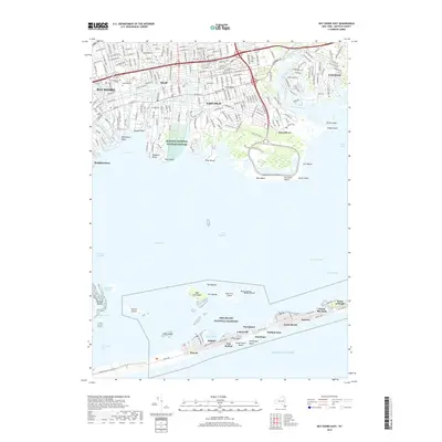
2019 Map of Bay Shore East
USGS Topo · Published 2019About this map
Great South Bay separates the densely developed suburban corridor of Long Island’s South Shore from the narrow, protective barrier of the Fire Island National Seashore. On the mainland, the residential blocks of Bay Shore, Islip, and East Islip are defined by a series of south-flowing tidal inlets, including Orowoc Creek and Watchogue Creek. This coastal landscape is marked by substantial public lands and conservation areas, such as the Seatuck National Wildlife Refuge and the recreational grounds at Timber Point. Across the West Channel, the Fire Island communities of Saltaire, Fair Harbor, and Ocean Beach appear as a string of pedestrian-oriented settlements between the bay and the Atlantic Ocean. The presence of Saint Patricks Cem and the Long Island rail line provides a anchor for local genealogical research in this long-settled maritime region.
Find a feature on this map
110 named features on this map. Tap any name to fly to it.
Don’t see what you’re looking for? This feature index may not catch every label — zoom into the map to look around manually.
Map Details
Editions of this 2019 Bay Shore East Map
This is the sole edition of this map. No revisions or reprints were ever made.
Other maps of this area

1901 · Babylon
USGS Topo · 1:62,500

1901 · Northport
USGS Topo · 1:62,500

1902 · Setauket
USGS Topo · 1:62,500

1902 · Fire Island
USGS Topo · 1:62,500

1903 · Babylon
USGS Topo · 1:62,500

1903 · Northport
USGS Topo · 1:62,500

1903 · Fire Island
USGS Topo · 1:62,500

1904 · Setauket
USGS Topo · 1:62,500

1904 · Islip
USGS Topo · 1:125,000

1919 · Setauket
USGS Topo · 1:62,500