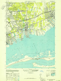
1941 Map of Bay Shore West
USGS Topo · Published 1941About this map
Babylon and the surrounding South Shore communities are captured here just before the massive post-war suburban expansion. This 1941 aerial photography base reveals a landscape defined by its coastal orientation, where the Long Island Railroad and the Sunrise Highway provided the primary arteries for local growth. The map shows the dense grid of Bay Shore and the established recreational character of the waterfront, highlighted by the Babylon Yacht Club and the Southward Ho Country Club.
Find a feature on this map
54 named features on this map. Tap any name to fly to it.
Don’t see what you’re looking for? This feature index may not catch every label — zoom into the map to look around manually.
Map Details
Editions of this 1941 Bay Shore West Map
This is the sole edition of this map. No revisions or reprints were ever made.
Other maps of this area

1901 · Babylon
USGS Topo · 1:62,500

1901 · Northport
USGS Topo · 1:62,500

1902 · Setauket
USGS Topo · 1:62,500

1902 · Fire Island
USGS Topo · 1:62,500

1903 · Babylon
USGS Topo · 1:62,500

1903 · Northport
USGS Topo · 1:62,500

1903 · Fire Island
USGS Topo · 1:62,500

1904 · Setauket
USGS Topo · 1:62,500

1904 · Islip
USGS Topo · 1:125,000

1919 · Setauket
USGS Topo · 1:62,500