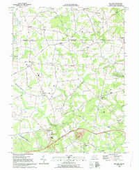
1992 Map of Bay View
USGS Topo · Published 1993About this map
Big Elk Creek and Little Elk Creek wind through the northeast corner of this Cecil County landscape, where the Pennsylvania Maryland border defines the northern limit of the survey. The terrain is a network of small crossroad settlements and rural institutions, from the academic grounds of Cecil Community College near Bay View to the industrial history at Elk Mills. Local genealogy is well-documented through numerous family-named landmarks and houses of worship, including Moores Chapel Cem, Rosebank Cem, and St Johns Ch. The map captures a moment of modern connectivity with the John Kennedy Memorial Highway and Toll Road cutting across the southern portion, yet traditional features like the Covered Bridge on the Pennsylvania line remain. Researchers can trace the layout of small communities such as Chrome, Lombard, and Calvert as they appeared in the early 1990s.
Find a feature on this map
84 named features on this map. Tap any name to fly to it.
Don’t see what you’re looking for? This feature index may not catch every label — zoom into the map to look around manually.
Map Details
Editions of this 1992 Bay View Map
This is the sole edition of this map. No revisions or reprints were ever made.
Other maps of this area

1898 · Elkton
USGS Topo · 1:62,500

1900 · Elkton
USGS Topo · 1:62,500

1900 · Havre De Grace
USGS Topo · 1:62,500

1904 · Coatesville
USGS Topo · 1:62,500

1906 · Coatesville
USGS Topo · 1:62,500

1912 · Quarryville
USGS Topo · 1:62,500

1917 · Elkton
USGS Topo · 1:62,500

1918 · Coatesville
USGS Topo · 1:62,500

1942 · Havre De Grace
USGS Topo · 1:62,500

1942 · Elkton
USGS Topo · 1:62,500