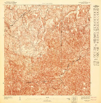
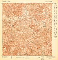
1947 Map of Bayaney NE
USGS Topo · Published 1947About this map
Bayaney serves as the primary settlement hub in this 1:10,000 scale preliminary study, which was produced just after World War II using topography surveyed in 1943. The landscape is defined by the complex karst topography of the northern interior, where the Tanama River cuts through the limestone terrain and the drainage of Hoya Caña marks the northern reaches. This document highlights the administrative boundaries of the era, showing the intersection where the Municipio de Hatillo, Municipio de Arecibo, and Municipio de Utuado meet. The map captures the fine-grained road network and structure density of the rural countryside during a period of transition for Puerto Rico's interior municipalities, providing a clear record of land use and property boundaries before mid-century development shifted the local settlement patterns.
Find a feature on this map
6 named features on this map. Tap any name to fly to it.
Don’t see what you’re looking for? This feature index may not catch every label — zoom into the map to look around manually.
Map Details
Editions of this 1947 Bayaney NE Map
This is the sole edition of this map. No revisions or reprints were ever made.
Other maps of this area

1938 · Camuy
USGS Topo · 1:20,000

1942 · Arecibo
USGS Topo · 1:30,000

1942 · Camuy
USGS Topo · 1:30,000

1946 · Utuado
USGS Topo · 1:30,000

1946 · Bayaney
USGS Topo · 1:30,000

1946 · Arecibo
USGS Topo · 1:30,000
1947 · Arecibo SO
USGS Topo · 1:10,000
1947 · Utuado SO
USGS Topo · 1:10,000
1947 · Utuado NO
USGS Topo · 1:10,000
1947 · Bayaney SE
USGS Topo · 1:10,000