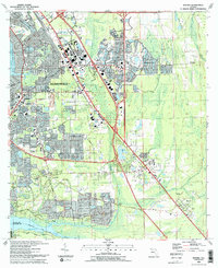
1993 Map of Bayard
USGS Topo · Published 1993About this map
St Johns River and the sweeping Julington Creek define the western and southern reaches of this landscape, framing a period of significant suburban expansion in southeast Jacksonville. The map documents a dense network of neighborhoods and community centers, including Mandarin and Loretto, where local landmarks like St Joseph Ch and Loretto Sch serve as focal points for the community. The presence of the Florida East Coast RR running parallel to St Augustine Road underscores the historical transportation corridor that facilitated the growth of settlements like Sunbeam and Bayard.
Find a feature on this map
70 named features on this map. Tap any name to fly to it.
Don’t see what you’re looking for? This feature index may not catch every label — zoom into the map to look around manually.
Map Details
Editions of this 1993 Bayard Map
2 editions found
Other maps of this area

1917 · Orange Park
USGS Topo · 1:62,500

1918 · Jacksonville
USGS Topo · 1:62,500

1918 · Orange Park
USGS Topo · 1:62,500

1918 · Palm Valley
USGS Topo · 1:62,500

1918 · Mayport
USGS Topo · 1:62,500

1948 · Jacksonville
USGS Topo · 1:250,000

1948 · Jacksonville Beach
USGS Topo · 1:24,000

1949 · Jacksonville Beach
USGS Topo · 1:24,000

1950 · Arlington
USGS Topo · 1:24,000
1950 · Jacksonville
USGS Topo · 1:24,000
Featured Places
- Jacksonville, FL
- Greenland, Jacksonville
- San Jose, Jacksonville
- Bayard, Jacksonville
- Stockade, Jacksonville