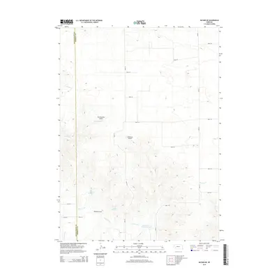
2014 Map of Bayard NE
USGS Topo · Published 2014About this map
Agricultural irrigation systems define the landscape across the Scotts Bluff and Morrill county line in western Nebraska. A complex network of water management features, including the Highline Canal, the High Line Canal, and the Lowline Canal, illustrates the region's reliance on managed water for prairie farming. These canals weave through a terrain marked by significant seasonal drainages like Ninemile Cr and its eastern branch, E Ninemile Cr. Notable catchment areas such as Ross Canyon Reservoir, Funk Reservoir, and Wildhorse Reservoir 9-A are positioned to capture runoff from the deep cuts of Wildhorse Canyon and East Ninemile Canyon. The map reveals a strictly gridded system of rural roads, including Road 75 and Road 136, which facilitate movement between these remote water works and the surrounding ranchlands.
Find a feature on this map
25 named features on this map. Tap any name to fly to it.
Don’t see what you’re looking for? This feature index may not catch every label — zoom into the map to look around manually.
Map Details
Editions of this 2014 Bayard NE Map
This is the sole edition of this map. No revisions or reprints were ever made.
Other maps of this area

1898 · Camp Clarke
USGS Topo · 1:125,000

1948 · Hemingford 4 SW
USGS Topo · 1:24,000

1951 · Kilpatrick Lake
USGS Topo · 1:62,500

1954 · Scottsbluff
USGS Topo · 1:250,000

1955 · Alliance
USGS Topo · 1:250,000

1957 · Alliance
USGS Topo · 1:250,000

1958 · Alliance
USGS Topo · 1:250,000

1958 · Scottsbluff
USGS Topo · 1:250,000

1965 · Bayard
USGS Topo · 1:24,000
1965 · Bayard NE
USGS Topo · 1:24,000