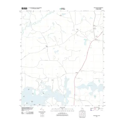
2011 Map of Beachton
USGS Topo · Published 2011About this map
Lake Iamonia and the Ochlockonee River define this Georgia-Florida borderland, where several smaller settlements and family-named landmarks mark the transition from river plains to higher ground. The map details the rural character of the region near Beachton and Moncrief, showing a landscape dotted with historically significant burial grounds such as New Ochlockonee Cemetery, Evergreen Cemetery, and Van Brunt Cemetery. To the west, the river system is fed by Buck Creek and Hadley Creek, while the southern portion of the sheet is dominated by the islands and points of the lake, including Lester Island, Sheep Island, and Mitchell Point. The network of roads, including Hadley Ferry Rd and Meridian Rd, suggests a long history of overland travel connecting these border communities. To the east, Foshalee Slough and Carns Pond further illustrate the water-rich geography of this low-lying area.
Find a feature on this map
42 named features on this map. Tap any name to fly to it.
Don’t see what you’re looking for? This feature index may not catch every label — zoom into the map to look around manually.
Map Details
Editions of this 2011 Beachton Map
This is the sole edition of this map. No revisions or reprints were ever made.
Other maps of this area

1954 · Tallahassee
USGS Topo · 1:250,000

1955 · Whigham
USGS Topo · 1:62,500

1956 · Cairo
USGS Topo · 1:62,500

1956 · Calvary
USGS Topo · 1:24,000

1957 · Beachton
USGS Topo · 1:24,000

1957 · Miccosukee NE
USGS Topo · 1:24,000

1959 · Tallahassee
USGS Topo · 1:250,000

1960 · Tallahassee
USGS Topo · 1:250,000
1963 · Bradfordville
USGS Topo · 1:24,000

1963 · Lake Jackson
USGS Topo · 1:24,000