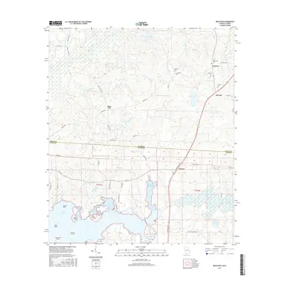
2017 Map of Beachton
USGS Topo · Published 2017About this map
Lake Iamonia and its intricate northern shorelines dominate this landscape where the Georgia-Florida state line divides Grady and Leon counties. The topography shifts from the wetlands of Anders Flat and Foshalee Slough to the prominent rise of Rocky Hill near the Ochlocknee River. Settlement patterns are concentrated around the crossroads of Beachton and Moncrief, which are connected by historic corridors like Meridian Rd and Thomasville Rd. Genealogists can trace family heritage through numerous burial grounds, including New Ochlocknee Cem and Van Brunt Cem, while local historians can examine the complex finger-like bays of the lake, such as Wych Arm and Strickland Arm, which define the water-bound economy and geography of the border region.
Find a feature on this map
56 named features on this map. Tap any name to fly to it.
Don’t see what you’re looking for? This feature index may not catch every label — zoom into the map to look around manually.
Map Details
Editions of this 2017 Beachton Map
This is the sole edition of this map. No revisions or reprints were ever made.
Other maps of this area

1954 · Tallahassee
USGS Topo · 1:250,000

1955 · Whigham
USGS Topo · 1:62,500

1956 · Cairo
USGS Topo · 1:62,500

1956 · Calvary
USGS Topo · 1:24,000

1957 · Beachton
USGS Topo · 1:24,000

1957 · Miccosukee NE
USGS Topo · 1:24,000

1959 · Tallahassee
USGS Topo · 1:250,000

1960 · Tallahassee
USGS Topo · 1:250,000
1963 · Bradfordville
USGS Topo · 1:24,000

1963 · Lake Jackson
USGS Topo · 1:24,000