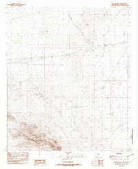
1982 Map of Beacon Hill
USGS Topo · Published 1982About this map
The Animas Mountains and the winding path of the Continental Divide dominate this high-desert landscape in Hidalgo County. This provisional survey captures a quiet corner of New Mexico where transportation infrastructure reflects both historical and modern utility. An Old Railroad Grade traverses the northern portion of the map, while a modern Pipeline On North Side Of Road and scattered Jeep Trails show the evolving use of the land. Human presence is sparse, centered primarily around a Trailer Park and several resource extraction sites like the Gravel Pit. The map is punctuated by prominent physical landmarks such as Beacon Hill and several small-scale water management features including a Check Dam, which speak to the importance of water and elevation in this arid environment during the late 1970s and early 1980s.
Find a feature on this map
9 named features on this map. Tap any name to fly to it.
Don’t see what you’re looking for? This feature index may not catch every label — zoom into the map to look around manually.
Map Details
Editions of this 1982 Beacon Hill Map
This is the sole edition of this map. No revisions or reprints were ever made.
Other maps of this area

1918 · Playas
USGS Topo · 1:62,500

1918 · Pratt
USGS Topo · 1:62,500

1919 · Pratt
USGS Topo · 1:62,500

1919 · Playas
USGS Topo · 1:62,500

1954 · Silver City
USGS Topo · 1:250,000

1955 · Douglas
USGS Topo · 1:250,000

1958 · Silver City
USGS Topo · 1:250,000

1959 · Douglas
USGS Topo · 1:250,000

1961 · Douglas
USGS Topo · 1:250,000

1962 · Silver City
USGS Topo · 1:250,000