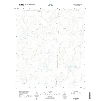
2019 Map of Bead Mountain
USGS Topo · Published 2019About this map
Valera occupies the northern edge of this landscape, where the Valera Cem is situated near the upper reaches of Home Creek. The geography here is defined by a significant water management network, evidenced by numerous Soil Conservation Service sites, including the large Soil Conservation Service Site 11 Reservoir near the southern boundary. These reservoirs are integrated into the drainage patterns of Panther Creek and Little Panther Creek, illustrating a highly engineered approach to the ranching and agricultural lands of central Coleman County. In the northwest, the terrain rises toward Bead Mountain, a distinct landmark overlooking Elm Creek. To the south, the Voss Cem is located along FM 503, providing a touchstone for local genealogy and family history in this cattle-country environment.
Find a feature on this map
30 named features on this map. Tap any name to fly to it.
Don’t see what you’re looking for? This feature index may not catch every label — zoom into the map to look around manually.
Map Details
Editions of this 2019 Bead Mountain Map
This is the sole edition of this map. No revisions or reprints were ever made.
Other maps of this area

1887 · Coleman
USGS Topo · 1:125,000

1889 · Coleman
USGS Topo · 1:125,000

1892 · Ballinger
USGS Topo · 1:125,000

1925 · Ballinger 4-c
USGS Topo · 1:48,000

1932 · Voss
USGS Topo · 1:62,500

1954 · Brownwood
USGS Topo · 1:250,000
1962 · Gouldbusk
USGS Topo · 1:24,000
1963 · Coleman
USGS Topo · 1:24,000
1964 · Fisk
USGS Topo · 1:24,000

1967 · Talpa
USGS Topo · 1:24,000