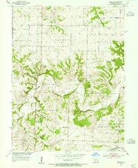
1953 Map of Beaman
USGS Topo · Published 1955About this map
Beaman sits at the junction of the Missouri Kansas Texas railroad in this mid-century look at eastern Pettis County. The landscape is defined by the winding course of Muddy Creek and its many tributaries, including Turkey Creek and Sewer Creek, which carve through the townships of Longwood, Hughesville, and Heaths Creek. This period reveals a densely settled rural community supported by a high concentration of local institutions, many of which were already changing, such as the Woodland Sch (Abandoned).
Find a feature on this map
31 named features on this map. Tap any name to fly to it.
Don’t see what you’re looking for? This feature index may not catch every label — zoom into the map to look around manually.
Map Details
Editions of this 1953 Beaman Map
2 editions found
Other maps of this area

1887 · Sedalia
USGS Topo · 1:125,000

1894 · Sedalia
USGS Topo · 1:125,000

1939 · Sweet Springs
USGS Topo · 1:62,500

1940 · Sweet Springs
USGS Topo · 1:62,500

1941 · Sweet Springs
USGS Topo · 1:62,500

1944 · Sedalia West
USGS Topo · 1:24,000

1944 · Sedalia East
USGS Topo · 1:24,000

1945 · Sweet Springs
USGS Topo · 1:62,500

1946 · Sedalia West
USGS Topo · 1:24,000

1946 · Sedalia East
USGS Topo · 1:24,000