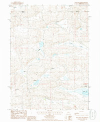
1985 Map of Bean Soup Lake
USGS Topo · Published 1986About this map
The isolated ranching landscapes of Arthur County and Grant County are meticulously documented in this mid-1980s topographical record. The terrain is defined by a series of closed depressions and interdunal basins, many holding named bodies of water such as Bean Soup Lake and Mechoglan Lake. The map illustrates a specialized land-use pattern where human presence is concentrated around family-named ranching outposts, including A Kramer Ranch, C Kramer Ranch, and both the R Ellingrod and B Ellingrod properties. These sites are linked by unimproved roads and trails winding through the natural troughs of Winslow Valley and Baldy Valley. The lack of conventional townsites highlights the characteristic Sandhills settlement pattern, where life revolves around the water sources and grazing lands necessary for cattle operations. Researchers can trace the specific spatial relationship between these homesteads and features like Threemile Lake and Claw Hammer Lake.
Find a feature on this map
13 named features on this map. Tap any name to fly to it.
Don’t see what you’re looking for? This feature index may not catch every label — zoom into the map to look around manually.
Map Details
Editions of this 1985 Bean Soup Lake Map
This is the sole edition of this map. No revisions or reprints were ever made.
Other maps of this area

1948 · Carr Lake
USGS Topo · 1:62,500

1948 · Spring Valley
USGS Topo · 1:62,500

1949 · Arthur
USGS Topo · 1:62,500

1949 · Flats
USGS Topo · 1:62,500

1950 · Flats
USGS Topo · 1:62,500

1950 · Spring Valley
USGS Topo · 1:62,500

1950 · Carr Lake
USGS Topo · 1:62,500

1950 · Arthur
USGS Topo · 1:62,500

1954 · North Platte
USGS Topo · 1:250,000

1956 · North Platte
USGS Topo · 1:250,000