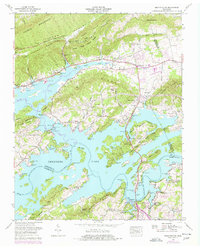
1960 Map of Bean Station
USGS Topo · Published 1977About this map
The Dixie Highway and Lee Highway intersect at Bean Station, a historic transportation hub where the Southern railroad once paralleled the base of Poor Valley Ridge. This 1960s landscape shows the profound impact of the Tennessee Valley Authority's work, with the waters of Cherokee Lake and the Holston River flooding the valleys surrounding Richland Ridge and Boatman Mountain. The map details the transition from rural valley farming to a recreation-oriented economy, evident in the German Creek Cabin Area, German Creek Dock, and a golf course near the historic Tate Springs area.
Find a feature on this map
71 named features on this map. Tap any name to fly to it.
Don’t see what you’re looking for? This feature index may not catch every label — zoom into the map to look around manually.
Map Details
Editions of this 1960 Bean Station Map
3 editions found
Other maps of this area

1883 · Morristown
USGS Topo · 1:125,000

1893 · Morristown
USGS Topo · 1:125,000

1895 · Morristown
USGS Topo · 1:125,000

1935 · Rogersville
USGS Topo · 1:48,000

1935 · Tate Springs
USGS Topo · 1:48,000

1935 · Lee Valley
USGS Topo · 1:24,000

1935 · Springvale
USGS Topo · 1:24,000

1935 · Howard Quarter
USGS Topo · 1:24,000

1935 · Swan Island
USGS Topo · 1:24,000

1935 · Avondale
USGS Topo · 1:24,000