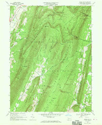
1967 Map of Beans Cove
USGS Topo · Published 1970About this map
Tussey Mountain and Warrior Ridge dominate this section of the Ridge-and-Valley Appalachians, creating the distinct north-south corridors that defined local settlement patterns in the late 1960s. The remote valley of Beans Cove sits between these high ridges, anchored by Seven Dolors Ch and the nearby Ruby Cem. This area reveals a landscape of transition where small agricultural pockets are hemmed in by the expansive Buchanan State Forest and State Game Lands No 97. To the south, the settlement of Hewitt marks a point of interest for local historians with its Covered Bridge and the Prosperity Ch. The map provides a detailed view of the high-elevation terrain around Martin Hill, where the Radio Tower Lookout Tower overlooks complex gaps such as Pigeonroost Gap and Sweet Root Gap.
Find a feature on this map
50 named features on this map. Tap any name to fly to it.
Don’t see what you’re looking for? This feature index may not catch every label — zoom into the map to look around manually.
Map Details
Editions of this 1967 Beans Cove Map
4 editions found
Other maps of this area

1898 · Paw Paw
USGS Topo · 1:62,500

1899 · Flintstone
USGS Topo · 1:62,500

1900 · Pawpaw
USGS Topo · 1:62,500

1900 · Flintstone
USGS Topo · 1:62,500

1910 · Paw Paw
USGS Topo · 1:62,500

1927 · Clearville
USGS Topo · 1:48,000

1927 · Hyndman
USGS Topo · 1:62,500

1931 · Clearville
USGS Topo · 1:62,500

1931 · Hyndman
USGS Topo · 1:62,500

1944 · Hyndman
USGS Topo · 1:62,500
Featured Places
- Colerain Township, PA
- Cumberland Valley Township, PA
- Southampton Township, PA
- Beans Cove, Southampton Township
- Monroe Township, PA