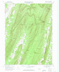
1967 Map of Beans Cove
USGS Topo · Published 1973About this map
Tussey Mountain and Martin Mountain dominate this section of the Ridge-and-Valley Appalachians in southern Bedford County. The landscape is defined by long, narrow ridges separated by agricultural valleys like Cumberland Valley and Black Valley. Small mountain communities such as Beans Cove and Hewitt anchor the lowlands, while much of the high ground is protected within the Buchanan State Forest.
Find a feature on this map
49 named features on this map. Tap any name to fly to it.
Don’t see what you’re looking for? This feature index may not catch every label — zoom into the map to look around manually.
Map Details
Editions of this 1967 Beans Cove Map
4 editions found
Other maps of this area

1898 · Paw Paw
USGS Topo · 1:62,500

1899 · Flintstone
USGS Topo · 1:62,500

1900 · Pawpaw
USGS Topo · 1:62,500

1900 · Flintstone
USGS Topo · 1:62,500

1910 · Paw Paw
USGS Topo · 1:62,500

1927 · Clearville
USGS Topo · 1:48,000

1927 · Hyndman
USGS Topo · 1:62,500

1931 · Clearville
USGS Topo · 1:62,500

1931 · Hyndman
USGS Topo · 1:62,500

1944 · Hyndman
USGS Topo · 1:62,500
Featured Places
- Colerain Township, PA
- Cumberland Valley Township, PA
- Southampton Township, PA
- Beans Cove, Southampton Township
- Monroe Township, PA