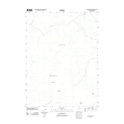
2011 Map of Bear Buttes
USGS Topo · Published 2011About this map
Chinatown sits as a central point of interest in this high-desert portion of Humboldt County, Nevada. The landscape is defined by its seasonal hydrology and volcanic topography, with various drainage systems including Sand Creek, Virgin Creek, and the arid Alkali Flat. These watercourses are supported by critical isolated water sources like Tenmile Spring, Rock Spring, and Trough Mountain Spring, which were historically vital for transit through this basin and range province.
Find a feature on this map
13 named features on this map. Tap any name to fly to it.
Don’t see what you’re looking for? This feature index may not catch every label — zoom into the map to look around manually.
Map Details
Editions of this 2011 Bear Buttes Map
This is the sole edition of this map. No revisions or reprints were ever made.
Other maps of this area

1889 · Long Valley
USGS Topo · 1:250,000

1954 · Vya
USGS Topo · 1:250,000

1958 · Vya
USGS Topo · 1:250,000

1962 · Vya
USGS Topo · 1:250,000

1965 · Rock Spring Table
USGS Topo · 1:62,500

1966 · Blowout Mtn
USGS Topo · 1:24,000

1966 · Badger Mtn SE
USGS Topo · 1:24,000

1972 · Soldier Meadow
USGS Topo · 1:24,000
1972 · Red Mountain
USGS Topo · 1:24,000
1972 · Yellow Hills East
USGS Topo · 1:24,000